Winter forecast 2020-2021 door Judah Cohen

7
Ieder jaar zorgt wetenschapper Judah Cohen voor zijn winter forecast op onze website. Deze winterupdate is gebaseerd op allerlei parameters die belangrijk zijn om de winterkansen op het Noordelijk Halfrond in te schatten. Dit artikel is uitzonderlijk in het Engels en zeker waardevol voor de weerliefhebber die zich wil verdiepen in winterkansen.
- Bekijk de weerberichten ook op Facebook of Twitter.
- We hebben bijna 10.000 euro ingezameld voor de NWBNLX-applicatie op uw smartphone. Help jij ook mee?
Deelnemen aan discussie? Ben je geïnteresseerd om deel te nemen als weeramateur of liefhebber van het weer aan het weerforum? Onderaan dit artikel krijg je bliksemsnel & gratis toegang tot alle reacties. Je kan ook je eigen weerfoto’s opladen.
La Niña
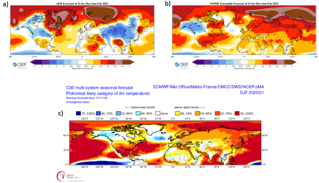
The most commonly used predictor in seasonal prediction is the El Niño/Southern Oscillation or (ENSO). Though government forecast centers rely mostly on dynamical models for seasonal forecasts, they are very sensitive to the phase of ENSO. From figure 1 it shows that this winter a moderate La Niña is predicted. A canonical La Niña pattern can be seen across North America. This yields below normal temperatures in the northwestern part of North America.
Also above normal temperatures elsewhere across the continent but especially in the Southeastern US. Across Eurasia the ENSO influence is weaker. Here the models default to a “global warming” forecast with above normal temperatures throughout the continent.
Arctic forcings
In contrast, I have focused my research on the contribution of Arctic forcings on mid-latitude weather. Especially on winter and at seasonal timescales. Much of my research has been on the relationship between October Siberian snow cover extent on winter surface temperature anomalies across the Northern Hemisphere (NH). When October Siberian snow cover is extensive, winter temperatures are relatively cold across Northern Eurasia.
This includes Northern Europe and the Eastern US with relatively mild temperatures across the Mediterranean, North Africa and Northeast Canada. Past October Siberian snow cover was above normal but less than one standard deviation. This by itself favors a relatively cold winter across the NH including Northern Europe. But admittedly the signal is not strong this year.
More recently I have also been researching the relationship between Arctic sea ice extent and winter weather. In general, reduced Arctic sea ice extent is related to cold temperatures across the NH but regionality is important. Low sea ice in the Barents-Kara Seas favor cold in Asia. Low sea ice in the Chukchi and Bering Seas favor cold in eastern North America. And low sea ice around Greenland favors cold in Northern Europe.
This fall the region that has experienced the greatest negative anomalies in sea ice extent has been the Barents-Kara Seas. I interpret the sea ice anomalies as favouring cold temperatures in Central and East Asia more so than in Europe or North America. And so far in December, Asia has experienced the most extensive below normal temperatures relative to normal. More so than Europe or North America.
I and others have argued that Siberian snow cover and Arctic sea ice can influence winter weather across the mid-latitudes through interactions with the polar vortex (PV). The PV is a fast-flowing ribbon or river of air that circumnavigates the Arctic high above the earth’s surface in the stratosphere. When the PV is strong, cold air remains confined over the Arctic while the mid-latitudes are relatively mild. But when the PV is perturbed or weak the Jet Stream becomes wavier allowing cold air from the Arctic to be transported to the mid-latitudes including Europe and the Eastern US. Both extensive October Siberian snow cover and diminished Arctic sea ice extent in the Barents-Kara Seas are related to a weaker or more perturbed winter PV and colder winter temperatures.
Quasi Biennial Oscillation
Another factor that could be important this winter is the phase of the quasi biennial oscillation (QBO). The phase of the QBO is determined by the sign of the winds in the equatorial stratosphere. When the winds are easterly or negative so is the QBO. When the winds are westerly or positive so is the QBO. Often the winds are from different directions at different levels. The winds in the lower stratosphere are considered most important for the behaviour of the PV. The winds in the lower equatorial stratosphere are currently westerly or positive.
There is both observational and modeling support that a westerly QBO favors a strong PV and relatively mild temperatures across the NH mid-latitudes including Europe. So even though Arctic forcing favors a disrupted PV, the QBO could be cancelling this forcing. However, during westerly QBO winters, chances increase for a PV disruption later in the winter.
In Figure 1, I also include the winter surface temperature anomalies from the AER statistical model. Major predictors used in the model are:
- predicted winter ENSO (Niño 3.4 index)
- estimated September Arctic sea ice concentration anomaly
- October Eurasian snow cover extent anomaly
- October sea level pressure (SLP) anomaly in northwestern Asia
The AER statistical model predicts relatively warm temperatures across much of Scandinavia, Southern Asia, Northeastern Canada and the Southern and Eastern US. This yields seasonable to cold temperatures across Western, Central Europe and Canada, Central and East Asia and Northwestern United States. The statistical model forecast can be interpreted as anticipating a weakened PV. This is followed by severe winter weather across northern Eurasia, Central Canada and the Northwestern United States.
Blocking
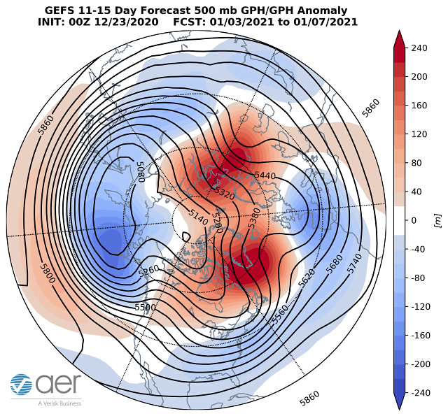
Last winter there was a complete absence of high latitude blocking (stagnant high pressure). High latitude blocking is critical for cold weather in the mid-latitudes. This winter there has been greater occurrence of high latitude blocking in particular near the Urals. Blocking centered near the Urals is critical for disrupting the PV. Based on the strength and persistence of Ural blocking, a significant weakening of the PV is expected sometime in January.
In Figure 2, I show the forecast of the mid-tropospheric circulation for early January. It still shows blocking near the Urals but also shows blocking near Greenland. The blocking near Greenland is already predicted to force troughing and colder temperatures across Western Europe. If that blocking near Greenland can push further north, that would likely favor even colder temperatures across Europe.
Split of Polar Vortex
The best chance for Northern and Western Europe to have a cold winter is for a PV split to occur. There are two types of PV disruptions displacements and splits. In a PV displacement the PV remains intact but is displaced off the North Pole and weakens. In a PV split the original PV splits into two sister vortices that tend to meander closer to the mid-latitudes. A nice example of a PV split occurred in February 2018. Following the PV split it turned much colder across Europe including Western Europe and at eventually in the Eastern US. It is important to point out a PV split also occurred in January 2019. Yet Europe still experienced a mild winter. So a PV split does not guarantee a cold winter for Northern Europe.
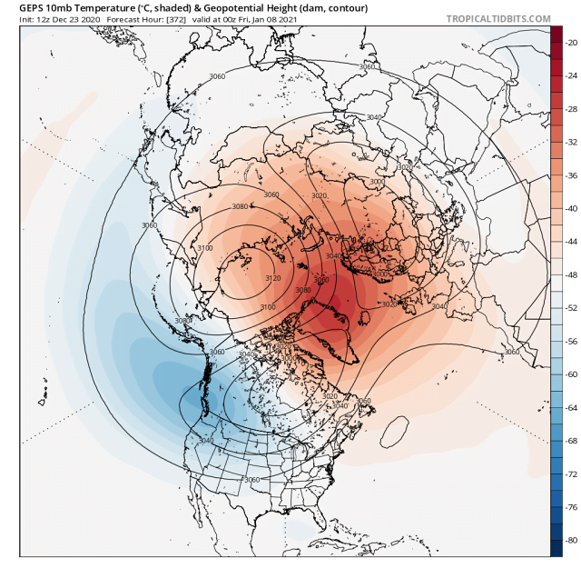
There are some strong signs in the weather models of a PV disruption, possibly even a split in early January. Typically, there is low pressure centered over the North Pole (PV). This is coupled with a strong belt of winds flowing from west to east near 60°N.
However, the forecast from the Canadian weather model (GEM) shows high pressure encroaching on the North Pole from Eastern Siberia. The main vortex is split into two daughter vortices. One over Western Russia and the other over Hudson Bay (Figure 3). Winds flow clockwise around high pressure and counterclockwise around low pressure. The winds in the stratosphere will blow from east to west across northwestern Eurasia. It is not a given, but if the same pattern in the stratosphere translates down into the troposphere then cold Siberian air could be drawn westward towards Northern Europe, ushering in a cold period across Northern Europe.
Conclusion
Based on extensive October snow cover and low Arctic sea ice, our model is predicting the best chances of a cold winter in Central and East Asia, Central Canada, the northwestern US and Western and Central Europe. The best chance for a cold winter in Northern Europe would be the occurrence of a PV split. There are signs that a PV split could occur in early January. But even if it does not occur early in the month, it is still possible later in the month. If a PV split occurs that would increase the chance of a cold winter across Northern Europe but not guarantee it. If a PV split does not occur this winter, then a mild winter is more likely across Europe.