Winterverwachting Judah Cohen


27 december 2019 -
8 min. lezen
3 reacties
Vandaag laten we de Engelstalige onderzoeker Judah Cohen aan het woord op NoodweerBenelux. Net als in 2018 schrijft hij vandaag een artikel over zijn inschatting voor de winter van 2019-2020. Die is meteorologisch gezien ondertussen al wel een maand bezig.
- Volg de weerupdates op de voet via Facebook en Twitter
- Volgen jullie al de weerberichten op Youtube?
Deelnemen aan discussie? Ben je geïnteresseerd om deel te nemen als weeramateur of liefhebber van winterweer aan het weerforum? Onderaan dit artikel krijg je bliksemsnel & gratis toegang tot alle reacties. Je kan ook je eigen weerfoto’s opladen.
Seasonal forecasts
The most commonly used predictor in seasonal prediction is the El Niño/Southern Oscillation or (ENSO). Though the government forecast centers rely mostly on dynamical models for seasonal forecasts, they are very sensitive to the phase of ENSO. However, this winter a neutral ENSO is predicted and therefore should have little influence on the weather across the globe, and the canonical ENSO pattern of variability is absent from the dynamical model forecasts.
I have focused my research on the contribution of Arctic forcings on mid-latitude weather especially on winter and at seasonal timescales. Much of my research has been on the relationship between October Siberian snow cover extent on winter surface temperature anomalies across the Northern Hemisphere (NH). When October Siberian snow cover is extensive, winter temperatures are relatively cold across Northern Eurasia including Northern Europe and the Eastern US with relatively mild temperatures across the Mediterranean, North Africa and Northeast Canada. This past October Siberian snow cover was the seventh most extensive on record (records began in the late 1960’s). This by itself favors a relatively cold winter across the NH including Northern Europe but admittedly the signal is not strong for Europe.
I have also been researching the relationship between Arctic sea ice extent and winter weather. In general, reduced Arctic sea ice extent is related to cold temperatures across the NH but regionality is important. Low sea ice in the Barents Kara Seas favor cold in Asia, low sea ice in the Chukchi and Bering Seas favor cold in eastern North America and low sea ice around Greenland favors cold in Northern Europe. This fall the region that has experienced the greatest negative anomalies in sea ice extent has been the Chukchi and Bering Seas, while sea ice has been more extensive in the Barents Kara Seas relative to other recent years.
I interpret the sea ice anomalies as favouring cold temperatures in eastern North America and East Asia more so than in Europe. One caveat is that sea ice is also low around Greenland. If that becomes more dominant it could should the probability towards increased cold weather across Northern Europe.
Polar Vortex
I and others have argued that Siberian snow cover and Arctic sea ice can influence winter weather across the mid-latitudes through interactions with the polar vortex (PV). The PV is a fast-flowing ribbon or river of air that circumnavigates the Arctic high above the earth’s surface in the stratosphere. When the PV is strong, cold air remains confined over the Arctic while the mid-latitudes are relatively mild but when the PV is perturbed or weak the jet stream becomes wavier or more meandering allowing cold air from the Arctic to be transported to the mid-latitudes including Europe and the Eastern US. Both extensive October Siberian snow cover and diminished Arctic sea ice extent in the Barents-Kara Seas are related to a weaker or more perturbed winter PV and colder winter temperatures.
Another factor that could be important this winter is the phase of the quasi biennial oscillation (QBO). The phase of the QBO is determined by the sign of the winds in the equatorial stratosphere. When the winds are easterly or negative so is the QBO and when the winds are westerly or positive so is the QBO. Often the winds are from different directions at different levels but the winds in the lower stratosphere are considered most important for the behaviour of the PV. The winds in the lower equatorial stratosphere are currently westerly or positive. There is both observational and modeling support that a westerly QBO favors a strong PV and relatively mild temperatures across the NH mid-latitudes including Europe. So even though Arctic forcing favors a disrupted PV, the QBO could be cancelling this forcing. However, during westerly QBO winters, chances increase for a PV disruption later in the winter.
I include the winter surface temperature anomalies from three dynamical model products and from the AER statistical model. The first model forecast is from NOAA’s CFSv2 (climate forecast system version 2), the second model forecast is from the North American Multi-Model Ensemble (NMME). The NMME system includes coupled models from a number of US and Canadian modeling centers. The third forecast is from the C3S an international suite of models including the European Centre for Medium-range Weather Forecasting (ECMWF) model, the UK Met Office Hadley Center Unified Model and the MeteoFrance model. The final forecast is from the AER statistical model. The major predictors used in the model are predicted winter ENSO (Niño 3.4 index), estimated September Arctic sea ice concentration anomaly, October Eurasian snow cover extent anomaly and October sea level pressure (SLP) anomaly in northwestern Asia.
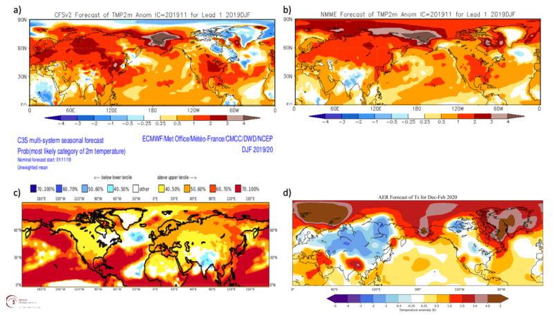
All of the dynamical models show a similar forecast with widespread relatively warm temperatures across the NH including all of Asia, the United States including Alaska and most of Canada. In contrast the AER statistical model predicts relatively warm temperatures across much of Southern Asia, Southern Europe, Alaska and Northeastern Canada with seasonable to cold temperatures across Northern Asia, Northern Europe, Central Canada and the Northeastern United States. The statistical model forecast can be interpreted as anticipating a weakened PV followed by severe winter weather across northern Eurasia, Canada and the Northeastern United States.
Relative mild winter for Europe
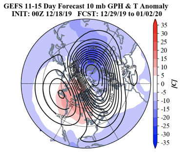
I think the best chance for Northern Europe to have a cold winter is for a PV split to occur. There are two types of PV disruptions displacements and splits. In a PV displacement the PV remains intact but is displaced off the North Pole and weakens. In a PV split the original one PV splits into two sister vortices that then tend to meander closer to the mid-latitudes. A nice example of a PV split occurred in February 2018. Following the PV split it turned much colder across Europe including Western Europe and at eventually in the Eastern US. But it is also important to point out a PV split also occurred in January 2019 and yet Europe still experienced a mild winter, so a PV split does not guarantee a cold winter for Northern Europe.
There are no signs in the weather models of a PV split in the foreseeable future. Instead the models are predicting a relatively minor PV disruption at the end of the year with the PV displaced towards the Urals and elongated. Also there is a ridge of high pressure centered near Alaska. The counterclockwise flow of wind around the PV center creates northerly flow across eastern North America driving cold air into eastern Canada and the US. This first happens in the stratosphere but quickly follows in the troposphere. This configuration favors cold in the Eastern US and Northern Asia but not Europe. Also its impact on the weather is relatively short-lived. If this minor PV disruption were to influence the weather its mostly likely timing is early January.
In conclusion, based on extensive October snow cover and low Arctic sea ice, our model is predicting the best chances of a cold winter are in East Asia, eastern North America and Northern Europe. However, because the greatest negative sea ice anomalies have been in the Chukchi and Bering Seas this fall, I believe this favors cold temperatures in East Asia and eastern North America more so than in Northern Europe.
The best chance for a cold winter in Northern Europe would be the occurrence of a PV split in my opinion. A westerly QBO is thought to be unfavorable for PV disruptions. However, the chances of a significant PV disruption does increase in the latter half of winter. I believe that in the absence of a PV split this winter Northern Europe is likely to experience a relatively mild winter.
Judah Cohen, Ph.D.
Director, Seasonal Forecasting
Atmospheric and Environmental Research (AER), a Verisk Business