Winterverwachting door Judah Cohen


4
Elk jaar zorgt de gerenommeerde, Amerikaanse wetenschapper Judah Cohen voor een exclusieve winter gastblog op onze website. In de blog schat hij aan de hand van verschillende (soms eigen ontwikkelde) parameters de kans op deftig winterweer in Europa eind deze winter in. De winterupdate is dus gebaseerd op allerlei parameters (ENSO, QBO …) die belangrijk zijn om de winterkansen op het Noordelijk Halfrond in te schatten. Dit artikel is uitzonderlijk in het Engels, maar is zeker waardevol voor menig weerliefhebber die zich wil verdiepen in winterkansen. Veel leesgenot!
- Volg onze weerupdates op de voet via Facebook en Twitter
- Volgen jullie al de weerberichten op Youtube?
- Bekijk het weerbericht voor komende dagen
Deelnemen aan discussie? Ben je geïnteresseerd om deel te nemen als weeramateur of liefhebber van het weer aan het weerforum? Onderaan dit artikel krijg je bliksemsnel & gratis toegang tot alle reacties. Je kan ook je eigen weerfoto’s opladen.
La Niña
We are currently in a triple dip La Niña (La Niña three years in a row) and many of the same forcings are common to the last two winters and the dynamical model forecasts are nearly identical to the past two winters. The most commonly used predictor in seasonal prediction is the El Niño/Southern Oscillation or (ENSO). The government forecast centres rely mostly on dynamical models for seasonal forecasts and they are very sensitive to the phase of ENSO (I would argue too sensitive). In Figure 1, I include the multi-model ensemble from the North American models (NNME; includes coupled models from a number of US and Canadian modeling centers) and from the European models (C3S) including the European Centre for Medium-range Weather Forecasting (ECMWF) model, the UK Met Office Hadley Center Unified Model and the and the MeteoFrance model.
This winter a weak to moderate La Niña was predicted and a canonical La Niña pattern can be seen across North America with below normal temperatures in the northwestern part of North America and above normal temperatures elsewhere across the continent including Eastern Canada and much of the US. Across Eurasia where ENSO influence is weaker the models default to a “global warming” forecast with above normal temperatures throughout the continent. The dynamical forecast are almost identical to the forecasts of the two previous winters.
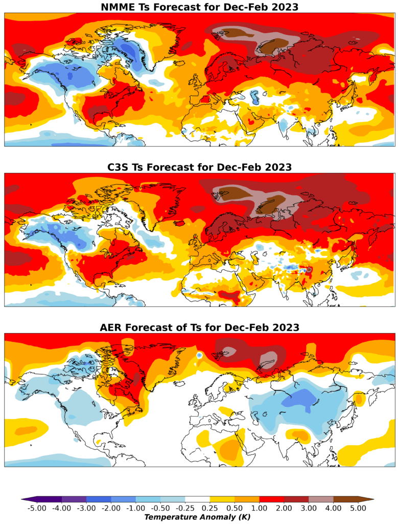
Figure 1. Predicted December 2022, January and February 2023 surface temperature anomalies from the NMME suite of models (top), the C3S suite of models (middle). The dynamical models are all initialized November 1, 2022 and the AER statistical model initialized November 21, 2022.
October Siberian snow cover
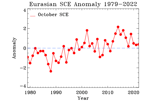
In contrast, I have focused my research on the contribution of Arctic forcings on mid-latitude weather especially on winter and at seasonal timescales. Much of my research has been on the relationship between October Siberian snow cover extent on winter surface temperature anomalies across the Northern Hemisphere (NH). When October Siberian snow cover is extensive, winter temperatures are relatively cold across Northern Eurasia including Northern Europe and the Eastern US with relatively mild temperatures across the Mediterranean, North Africa and Northeast Canada. This past October Siberian snow cover was slightly above normal but less than one standard deviation and similar to the last two Octobers (see Figure 2). This by itself favours a relatively cold winter across the NH most prominently in Northern Asia, but admittedly the signal is once again not strong this year.
Artic sea ice extent
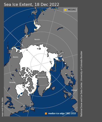
Recently I have also been researching the relationship between Arctic sea ice extent and winter weather. In general, reduced Arctic sea ice extent is related to cold temperatures across the NH but regionality is important. Low sea ice in the Barents-Kara Seas favours cold in Asia, low sea ice in the Chukchi and Bering Seas favour cold in eastern North America and low sea ice around Greenland favour’s cold in Northern Europe. This fall and early winter, the region that has experienced the greatest negative anomalies in sea ice extent has been in the Barents-Kara Seas (see Figure 3). I interpret the sea ice anomalies as favouring cold temperatures for Asia and less so for Europe. And so far, Europe has experienced some cold temperatures, but then it turned record warm at the end of december. In contrast the cold in Asia has been more persistent. In addition, the region of sea ice considered most influential for influencing the polar vortex and therefore weather outside of Asia elsewhere in the NH is the Barents-Kara Seas.
Polar Vortex disruptions
I and others have argued that Siberian snow cover and Arctic sea ice can influence winter weather across the mid-latitudes through interactions with the polar vortex (PV). The PV is a fast-flowing ribbon or river of air that circumnavigates the Arctic high above the earth’s surface in the stratosphere. When the PV is strong, cold air remains confined over the Arctic while the mid-latitudes are relatively mild but when the PV is perturbed or weak the Jet Stream becomes wavier or more meandering allowing cold air from the Arctic to be transported to the mid-latitudes including Europe and the Eastern US. Both extensive October Siberian snow cover and diminished Arctic sea ice extent in the Barents-Kara Seas are related to a weaker or more perturbed winter PV and colder winter temperatures. I do think that Arctic sea ice and snow depth across Siberia will play an important role influencing the behaviour of the PV. And currently snow depths across most (if not all) of Siberia are above normal (not shown).
Another factor that could be important this winter is the phase of the quasi biennial oscillation (QBO). The phase of the QBO is determined by the sign of the winds in the equatorial stratosphere. When the winds are easterly or negative so is the QBO and when the winds are westerly or positive so is the QBO. Often the winds are from different directions at different levels but the winds in the lower stratosphere are considered most important for the behaviour of the PV. The winds in the lower equatorial stratosphere are currently westerly or positive. There is both observational and modelling support that an westerly QBO favours a strong PV and relatively mild temperatures across the NH mid-latitudes including Europe. So even though Arctic forcing favours a disrupted PV, the westerly QBO and La Niña could be offsetting this forcing and favour a strong PV.
In Figure 1, I also include the winter surface temperature anomalies from the AER statistical model. The major predictors used in the model are predicted winter ENSO (Niño 3.4 index), estimated September Arctic sea ice concentration anomaly, October Eurasian snow cover extent anomaly and the October sea level pressure (SLP) anomaly in northwestern Asia. The AER statistical model predicts relatively warm temperatures across, Southern Asia, Eastern Canada and the Southern and Eastern US with seasonable to cold temperatures across Northern and East Asia, Western Canada and the Northwestern United States.
Last winter there was moderate high latitude blocking (stagnant high pressure) centered across Siberia and especially in the North Pacific. High latitude blocking is critical for cold weather in the mid-latitudes. This winter the occurrence of high latitude blocking has been focused near the Urals and in the central Arctic. Early in the winter there was Greenland blocking that brought a cold period to Europe in late November and early December.
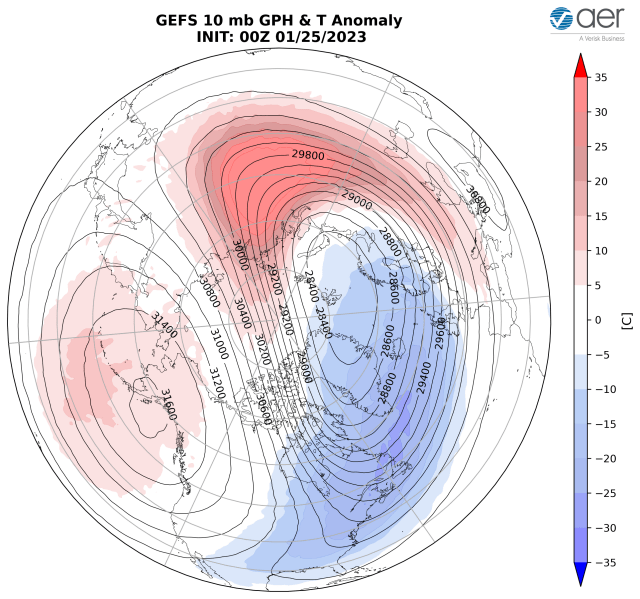
However, because the bocking near the Urals has been transitory it has resulted in only minor disruptions of the PV in December and January in the form of a stretched PV (see Figure 4). During these events the shape of the PV is not circular, which is the typical state, but instead the PV becomes stretched resulting in cross polar flow from Siberia to North America acting as a conduit for cold air from Siberia to Canada. A stretched PV favors cold and possibly extreme cold in Central to East Asia and especially North America mostly east of the Rockies. For Europe there doesn’t seem to be much of a relationship between a stretched PV and temperatures. Also, the cold anomalies tend to last for one to two weeks and not longer. The Ural blocking has been shifty, coming and going. This has favoured the stretched PVs every month since October but not the larger and longer lasting PV disruption known as a sudden stratospheric warming. However the stretched PVs brought extreme cold to North America in December and Asia in January.
Northern Europe has been cold overall in large part due to the strong Greenland blocking in December but the rest of Europe has been mild to even record mild. However, there exist few signs of a return to Greenland blocking and therefore I expect temperature to remain relatively mild across much of Europe through the remainder of the winter. As I have discussed previously, the best chance for Northern and Western Europe to have a cold winter is for a PV split to occur. There are two types of PV disruptions: displacements and splits. In a PV displacement the PV remains intact but is displaced off the North Pole and weakens. In a PV split the original one PV splits into two sister vortices that then tend to meander closer to the mid-latitudes. A nice example of a PV split occurred in February 2018. Following the PV split it turned much colder across Europe including Western Europe and at eventually in the Eastern US. Though a minor SSW will occur this week, there are no credible signs of a PV split but one could still occur in the coming weeks and months.
Conclusion
In conclusion, based on above normal October snow cover extent and La Niña our model is predicting the best chances of a cold (reamining) winter are in Central and East Asia, Western Canada and the Northwestern US. The best chance for a cold winter in Europe seems to be limited across Northern Europe including the UK and Scandinavia. For cold temperatures to be more widespread a PV split is necessary in my opinion. There are no signs that a PV split will occur in February based on the dynamical models. However, I do think there is a possibility of one, if Ural blocking can become more stationary and less transitory. But the best probability is for Europe to remain mostly mild through the end of the winter.